Don't worry, we are working...
#harjurbr
Half year since last post. I know, it's long time. There has been ups and downs, silence and rumours. Many things in the stage have been made couple times to get them right. A lot has been learned and lot will be learned before release.
What has been made to get here? Well... within almost two years we have worked hundreds of hours, taken hundreds of photos, edited hundreds of images, modelled over thousand objects, learned lot about track making, flied couple filming flights with drone and done many other things.
Aleksi's thoughts from last half year with Harju project:
The biggest hurdle in development for the past 6 months has been a complete rework of the ground texturing. As with almost everything else in this project, due to no experience we did it all wrong in the beginning. We used one 4k texture atlas for every ground texture - as it turned out, that wasn't very handy. All textures were in too low resolution - seamless UV wrapping going over the "borders" wasn't possible and the whole UV mapping was a lot harder as the whole ground was only a single material. This is clearly visible in the old progress pictures - for example the grass areas were all mapped inside a 256px square. Now, we have to give credit to the creators of the stage Biskupice, incredible work. We took a lot of inspiration from your work once the stage got released about the same time as we started the rework. As a result, we now have all "big" ground areas as their own material and own texture. This allows for much easier 1) seamless UV Mapping 2) possibility of updating the texture later 3) greater resolution and therefore variation in the texture. 4) more uniform uv mapping as the size of the polygon becomes irrelevant when the coordinates can go over the "borders".
For creating new ground textures, it turned out that taking photos with a drone is a massive help. It is much, much easier to create a new ground texture from a 4k top-down photo from a few meters above with good lighting, than it is from any photo taken by hand. I strongly recommend all serious track builders to invest in one, you won't know how useful it is until you get one. (not a paid promotion by any drone company smile ) Also, one big problem we had until this point was making the textures seamless. You can see this in the old pictures in the asphalt textures, they had a lot of darker and lighter stripes going across the road as the texture was far from perfect. We did some learning on that and it turns out, it wasn't so hard after all. We also got a lot better at making the transitions between textures, and how to UV map them properly. Once again, inspiration taken from the SS Biskupice texture folder. The ground geometry had to changed in places to allow for mapping the transitions properly. Among all other things, once again this small, completely hidden in the final product, work took it's time, and should've been done properly from the beginning. But this is all part of the learning curve, you can't expect to know all tricks when starting. It would be a boring task if you did slight_smile As of now, the stage has approximately 95% of "essential" individual objects done and placed. The biggest hurdle before the completion will be making good looking trees and other vegetation. There will have to be a line drawn somewhere - we obviously can't make every single tree and bush just like it is in real life, as opposed to the precision we have done with all other objects.
For the trees, we started experimenting with completely computer generated trees for the pines and birch trees, and making renders of them for low-poly game asset use. This has yielded very good results. The method allows us to use much better resolution in the trees as normal photos would do. We try to use as much 3D trunks in the trees as possible. Thanks to the precision of our laserscan data, we have hand-placed so far around 200 trees to their exact positions with, I'd say, about 5 centimeter accuracy. This will be a great thing for making the stage as real as possible as the gravel sections on the stage are really narrow, like Didier Auriol and others found out in the 1990's :)
 |
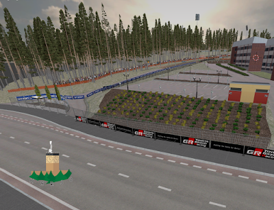
| Harju in Blender 6/2021. |
Comparison pairs, virtual vs. real:
 |
| Photo taken spring 2021. Grass looks worse at this time of year. |
 |
| Harju in Blender 6/2021. |
 |
| Harju August 2019. Photo: J. Laahanen |
 |
| Harju in Blender 6/2021. |
 |
| SS Harju 2019. Photo: Tomi Hänninen |
 |
| Harju in Blender 6/2021. |
- Harju Team , June 2021


Happy to hear Biskupice served well as an inspiration :) I am not sure about using a drone for getting textures though as there will be very tricky to achieve good blending and visual similarity with the existing ground textures.
VastaaPoistaWhat proved to work well for me instead, is to make a "base surfaces tiles" first - like gravel one, grass, forest ground etc. (you can find these in Biskupice called as "patterns").
Then you can create all the more specific textures (like gravel road, grass to gravel roadside etc.) by linking to these "base tiles" (google "Photoshop Linked Smart Objects") and blending them using masks etc. This approach will guarantee that all the textures blend to each other perfectly.
Blogin hallinnoija on poistanut tämän kommentin.
VastaaPoista